Clients
- National Science Foundation
- NASA
- New Hampshire Geological Survey
- Australian National University
- Southern Illinois University
- Irving Materials Inc.
Geoscy principal research collaborators
- Dr. S. Arcone, US Army Core of Engineers, Cold Regions Research and Engineering Laboratory
- Prof. G. Hope, Australian National University
- Prof. S. Ishman, Southern Illinois University
- Dr. A. Ismail, Illinois Geological Survey
- Dr. K. Ellett, Indiana Geological Survey
- Dr. S. Letsinger, Indiana University
- Dr. R. Perembo, University of Papua New Guinea
- Dr. A. Schimmelmann, Indiana University
- Dr. R. Sletton, University of Washington
- Dr. K. Maryunani, Institute of Technology at Bandung, Bandung Indonesia
GPR of Frozen Sediments in an Antarctic Desert
Geoscy has collected considerable GPR data on frozen glacial sediments in Antarctica in part to test the capability of GPR. The GPR profiles of these sediments is not influenced by water and sediment stratigraphy is largely known because vegetation is absent. Questions include: depth of penetration, ice content, identifying sediment lithologies, and the causes of reflection events.
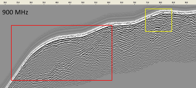
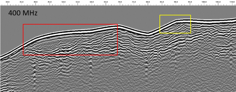
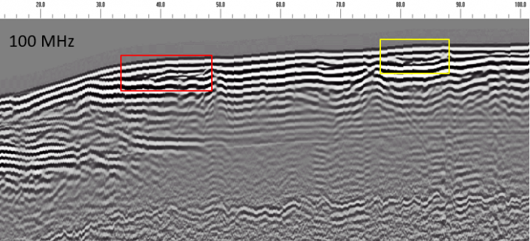
As a representative example, we collected several GPR profiles across a sandy Antarctic fluvial deposit using GPR antennas with central frequencies of 900, 400, and 100 MHz (see figures). Note the centimeter-scale cross-strata that the 900 MHz GPR antenna records outlined by red and yellow boxes. The 400 MHz GPR profile along the same transect shows the cross-strata in much less detail but this frequency penetrates deeper into the deposit than the 900 MHz antenna. The 100 MHz data does not resolve fine-scale cross-strata within the mesa but does show the architecture of major deposits within and beneath the mesa. Clearly, several frequencies are needed to recognize the multiple scales of stratification that typify fluvial deposits. It is also clear that GPR reflection events coincide with sedimentary bedding. This implies that they are caused by slight variations in grain-size frequency.

GPR profile collected using a 900 MHz antenna on a transect over a mesa-shaped Antarctic deposit (100 m long). This profile penetrates 2.5 m and shows deposits with fine-scale cross-strata within the red and yellow boxes.

GPR profile collected using 400 MHz antenna along the same 100 m transect shown for the 900 MHz profile above. 400 MHz data shows the same cross-stratified deposits (within red and yellow boxes) as the 900 MHz but with much less resolution. Deposit in yellow box is barely visible. Maximum penetration depth is ~ 4 m.

GPR profile collected using 100 MHz antenna along the same 100 m transect shown for the 900 MHz profile above. 100 MHz data does not resolve cross-strata within the red and yellow boxes but does represent the cross-stratified units with reflection event discontinuities. Maximum penetration depth of the 100 MHz data is ~10 m.
ERI of Mt Carmel Fault, Indiana
Geoscy investigated the Mt. Carmel fault in south-central Indiana using ERI. ERI results below show high-resistivity limestone bedrock (reds) at the lateral distance of 180-270 m adjacent to low-resistivity siltstone (greens and blues). The contact between the rock types is the Mt. Carmel fault. The ERI profile suggests that the fault dips steeply under the limestone.


Alternative models for inverted subsurface resistivity across the Mt. Carmel fault in Morgan County, Indiana, based on electrical resistivity imaging (ERI). Colors represent resistivity according to scale on right. All distances are in meters. a) Resistivity derived using the edge-gradient electrode array. b) Resistivity derived using the Wenner electrode array. The fault is between the high resistivity Herrodsberg limestone (reds) and low resistivity Borden siltstone (green-blue). The fault intersects the ground surface at a lateral distance of ~180 m.
