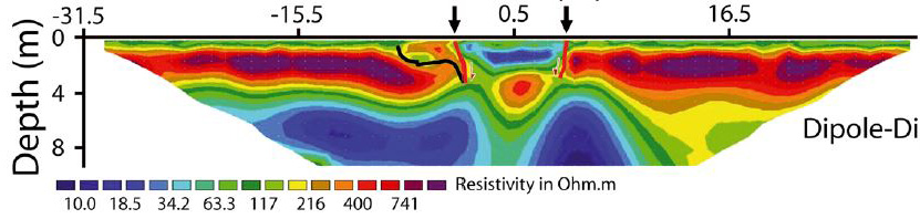
Carbonel et al. (2014) located a 12-14 m wide, filled collapse sinkhole in northeastern Spain using historical airphotos and ERI. Their ERI profile in Fig.1 shows a 2 m deep, elliptical zone of low resistivity (blues) which is the sinkhole itself now filled with a clay-rich rubble.
Fig. 1. ERI profile across a filled sinkhole collected using the dipole-dipole array. Colors represent resistivity according to the scale at diagram base. Horizontal and vertical dimensions are in meters. The high resistivity layer (reds) correspond to gravelly alluvium. ERI picked up a doughnut–shaped zone of low resistivity (blue) that clearly represents the sinkhole itself now filled with clayey rubble. ERI also shows the near-vertical edges of the sinkhole which indicates that it formed by collapse. Intermediate resistivity material on the edge of the sinkhole and at 4 m depth indicates that the sinkhole formerly wider is plugged with coarse rubble. Source: Carbonel et al. 2014
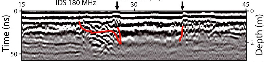
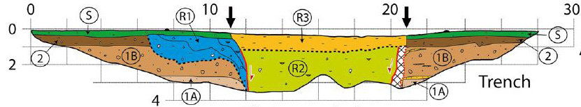
Using the ERI profiles for general location purposes, they precisely located the edges of the sinkhole using GPR (Fig. 2). They verified the geophysical surveys with extensive trenching and a borehole (Fig. 3). This work significantly improved the sinkhole inventory in the region. The results also indicate how the sinkhole formed, by collapse, which is crucial information for sinkhole prediction models. These are the building blocks for sinkhole risk assessment and management.
Fig. 2. GPR profile collected with 180 MHz antenna penetrates only to 3m. The GPR resolves the collapse structure based on lateral changes in reflections and small diffraction hyperbolas at edges. Relatively disturbed reflections and overlapping hyperbolas distinguish the coarse rubble on the erosional margin of the sinkhole.
Fig. 3. Geologic cross-section of collapse sinkhole. Clay-rich rubble (orange and olive colors: R2,R3) form the central plug of the collapse structure with near-vertical contacts. Coarse rubble (blue: R1) buries an erosional marginal step that dips away from the central plug. Gravelly alluvium (brown: 2) overlain by agricultural soil (green: S) and underlain by sandy alluvium (light brown:1) surrounds the sinkhole. Vertical fault planes (red) bound the central plug.